- About KC Streetcar
- Explore the Route
- How to Ride
- Employment
- News + Meetings
- Advertising & Opportunities
- Streetcar Swag
- RideKC Statement 2.15.2024
NorthRail
The original NorthRail Streetcar Study was completed in 2014 to assess feasibility and identify a preferred alternative for a northern streetcar extension from the River Market, across the Missouri River, into North Kansas City (NKC). The study included recommendations to facilitate pedestrian-oriented development and to support future transit expansion.
This 2022 NorthRail “refresh” study revisits the 2014 study to confirm alignments and options taking into account a myriad of changes in the past eight years, including:
- The opening of the Kansas City Streetcar downtown “starter” line, running from River Market to Union Station.
- The extension of the streetcar south on Main Street to the University of Missouri – Kansas City (UMKC) (the Main Street Extension is currently under construction).
- The extension of the streetcar north from the River Market to Berkley Riverfront Park (the Riverfront Extension is currently under construction).
- The significant growth, from commercial space to residential, that has occurred and is planned for NKC.
An extension of the streetcar system into NKC would support major themes in the city’s 2016 Master Plan, be a strategic investment in the future of NKC, and provide multimodal connectivity across the Missouri River. This study, funded jointly by NKC, the Kansas City Streetcar Authority (KCSA), and the Kansas City Area Transportation Authority (KCATA), revisited the technical and financial feasibility of a NorthRail extension while also determining the next steps of a streetcar extension into NKC.
This 2022 NorthRail “refresh” study built on the findings of the 2014 study, including the following assumptions:
- The Heart of America (HOA) bridge provides the most cost-effective means to cross the Missouri River.
- The NorthRail Extension will extend north, following either Burlington Street or Swift Street.
- East/west alignments were not evaluated as part of this effort, including extensions along Armour Road. Additional focus was placed on how a new NKC extension would connect to the existing and planned streetcar system in Kansas City, Missouri (KCMO), and how those systems would operate.
In November 2022, the consultant project team finalized the “refresh” NorthRail study with this report.
Click here to view a one page fact sheet about the 2022 NorthRail Streetcar Extension Study.
Previous Project News:
Study Begins To Take the KC Streetcar Over the River
The Kansas City Streetcar Authority (KCSA) is working with the City of North Kansas City, Missouri (NKC), and the Kansas City Area Transportation Authority (KCATA) to refresh the feasibility of a streetcar over the Missouri River. This study is estimated to be complete by the end of 2022. Click here for information about the project consultant team.
On June 28, 2022, the NorthRail project team held a public meeting and shared the recommendations on the Missouri River crossing options, preferred alignments, and stop locations to connect Downtown Kansas City with North Kansas City via an extension of the downtown KC Streetcar. Study findings and recommendations are based on technical analysis and input from North Kansas City residents and businesses, existing transit riders, and regional stakeholders.
Click here to view what was shared at the public meeting.
NorthRail Streetcar Study at a Glance:
The NorthRail Study investigated river crossing options, preferred alignment, and stop locations to connect Downtown Kansas City with North Kansas City via an extension of the existing downtown KC Streetcar. The study also includes a financial analysis of capital and operating costs, funding sources, and possible federal grant opportunities. The objective is to evaluate overall feasibility and reach consensus on a locally preferred alternative based on community input.
Simultaneous to this study, KCSA and partners are working to identify funding to advance the preferred plan towards environmental clearance, design, and related construction and operations funding.
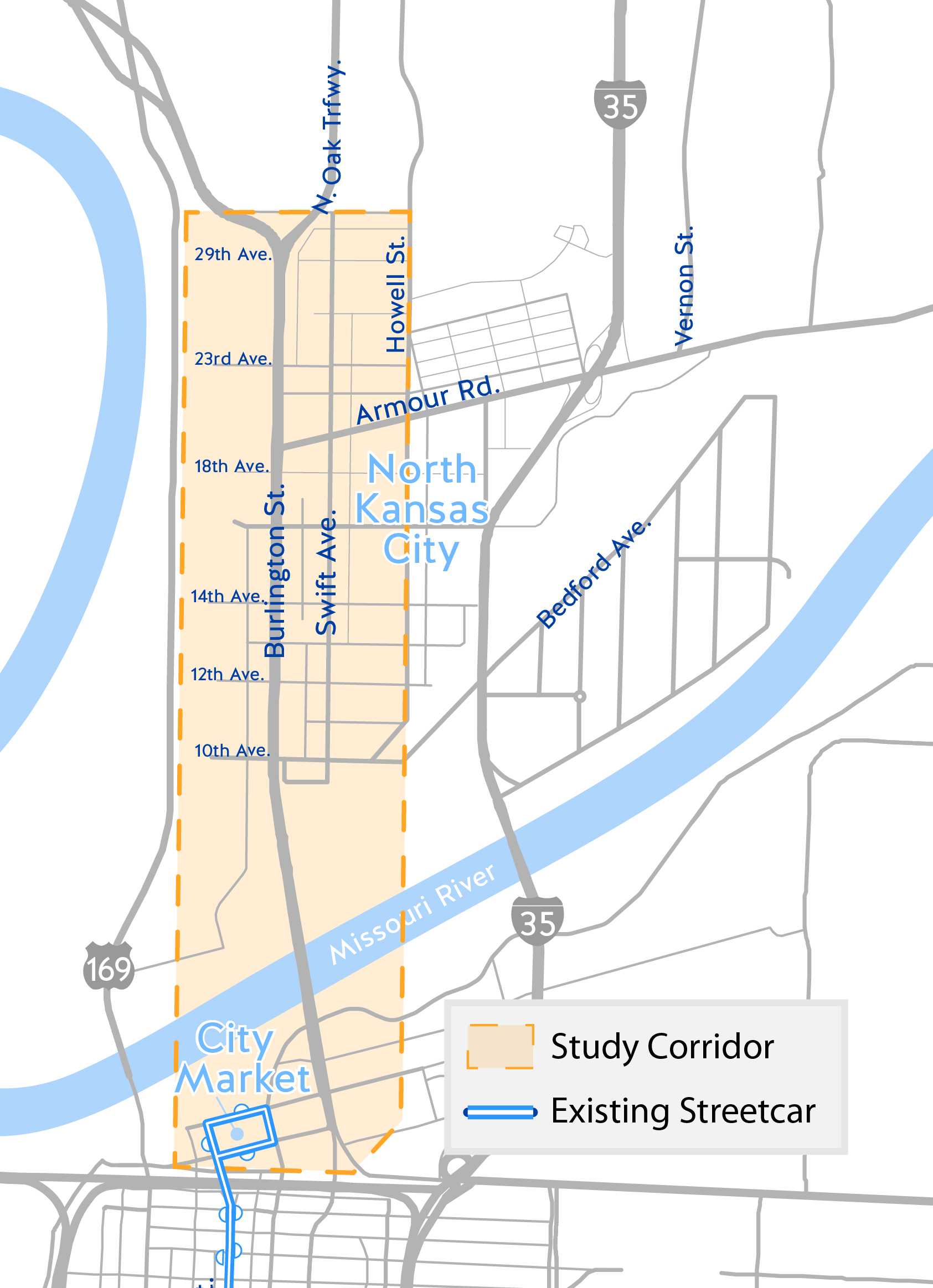 The primary study area extends from the existing downtown streetcar line in the River Market, across the Missouri River, to approximately 32nd Avenue in North Kansas City, Missouri. The study area is bounded on the west by the Armour-Swift-Burlington (ASB) Railroad Bridge and the BNSF railroad right of way and on the east by Charlotte and Swift Streets.
History
In 2014, the City of North Kansas City and the City of Kansas City, Missouri, conducted a preliminary study of a streetcar route north of the Missouri River. Results from the 2014 will help to inform the current study. The initial study was conducted prior to the opening of the existing downtown Streetcar line. Since 2014, the land use and development patterns in NKC have continued to evolve. An extension of the Streetcar system into NKC would support major themes in the City’s 2016 Master Plan, be a strategic investment in the future of NKC, and provide enhanced multi-modal connectivity across the Missouri River.
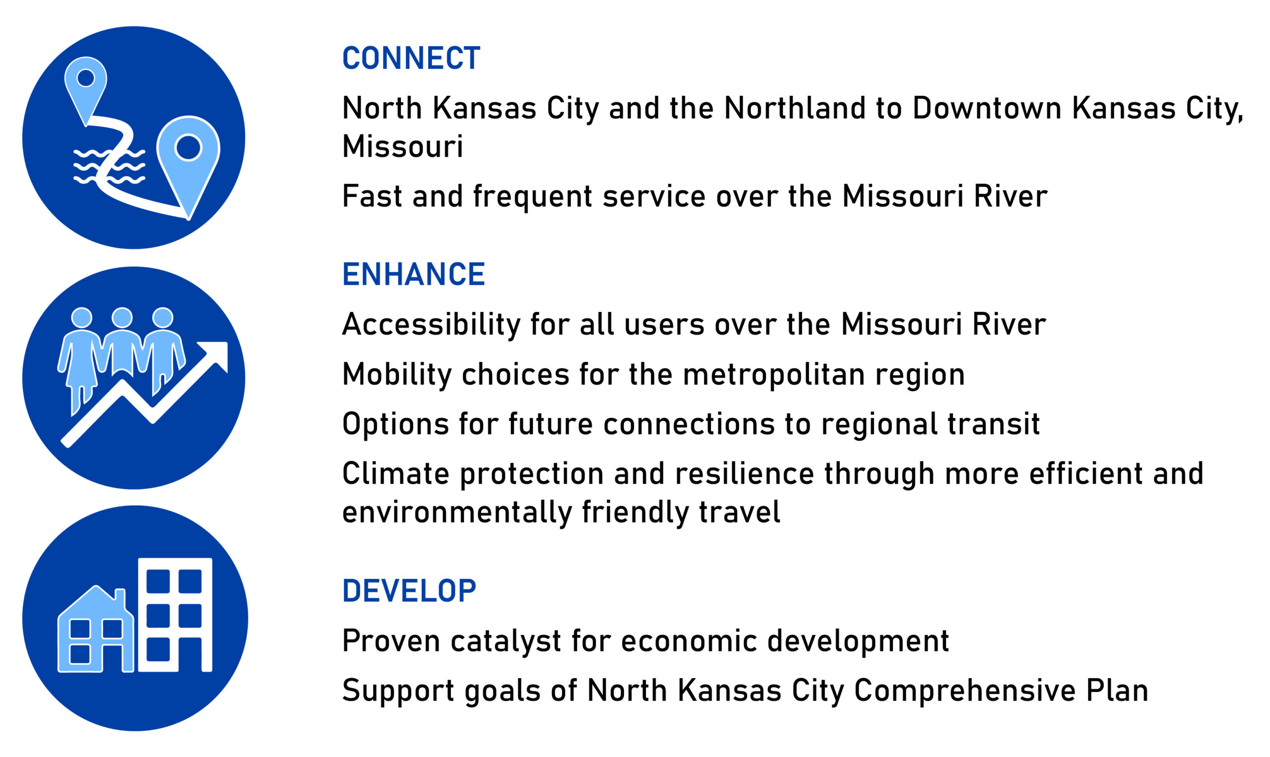
Purpose and Need of Project
A successful NorthRail Extension will Connect, Enhance, and Develop North Kansas City and its integration with the region-wide transportation network.
Screening of Initial Concepts
A number of initial alternatives were evaluated focusing on three separate, but connected, geographic areas:
- North of the Missouri River – what route options for NorthRail are viable to serve North Kansas City?
- Heart of America Bridge – if the Heart of America (Route 9) bridge is used to cross the Missouri River, how would the existing bridge be reconfigured to support the NorthRail extension?
- South of the Missouri River – once a new streetcar line crosses the Missouri River, how would NorthRail connect to the existing service?
Several initial concepts were evaluated to narrow down reasonable options for each segment to bring for public comment and to explore in further detail. These concepts were evaluated based on:
- Major Activity Centers Served – The number of schools, grocery stores, parks, etc. are within ¼-mile of the route.
- Demographics Served – The employment, population, and vulnerable population (poverty, minority, disabled, elderly, etc.) within a ¼-mile of the route.
- Technical Feasibility – The ease and ability to construct and operate.
- Operational Flexibility – The ability to support multiple operational scenarios for the streetcar (as an extension of the Main Street route, the ability to extend or connect to future extensions, etc.).
- Multimodal Integration – The impact to other means of travel, such as existing and planned transit (bus) routes, bicycle facilities, pedestrian facilities, and vehicular (auto and truck) operations.
- Economic Development Opportunities – The potential for the NorthRail to serve as a catalyst for new investments in real estate or businesses.
- Compatibility with Surrounding Land Uses – The ability to integrate and support existing land uses along the potential routes.
- Parking / Loading Impacts – The ability to support existing parking (on-street or off-street) as well as truck loading activities (impacts to loading docks).
- Right-of-Way Impacts – The amount of land and/or buildings that would need to be acquired.